Saturday, July 20, 2013

Glacier National Park!

Lake McDonald, which is just inside the west entrance into the park. 
McDonald Falls, on the northeast end of the lake. 
Hmmm. I must be gettin' old. I can't remember the name of the distant waterfall.
A tiny segment of the Going-to-the-Sun Road.
I shot this when I was on top of Logan Pass. Logan Pass is at elevation 6,646 feet.


I'm at Glacier National Park in Montana and it is beautiful! The weather is perfect and the scenery is spectacular! I've driven a lot of miles to get here but it has been worth it. I am not disappointed. This is a location that you have to put on your bucket list of places to visit.

By the time I arrived in Columbia Falls, it was late afternoon.  I got my trailer leveled and the utilities hooked-up and decided to make a quick run into the park to see what I could find. The sun sets late here so I still had several hours of daylight. I entered the park at West Glacier and took the Going-to-the-Sun Road up to Logan Pass before I decided it was time to turn around and head home. Just as a side note, when I first saw the name of the road, I thought it was kind of silly. But after driving on it, I understand how it got it's name. The road goes up and up and up and up!!! When I'd find a place to pull over and take pictures, I'd look ahead and see the road continuing upwards as far as I could see. But let me tell ya, the road is very narrow in places, enough so until I thought I might lose the mirrors on my truck. So far, so good. I still have my mirrors!

Until next time!


Sunday, July 14, 2013

Along the way!

My first view of Scott's Bluff National Monument.

Overlooking the North Platte River.

This is just to the west of Scott's Bluff National Monument.

Sunset. 
Once again, I'm having to play catch-up. I've put quite a few miles behind me since my last post and have taken lots of pictures since then. After leaving the Texas hill country, I stopped in the Texas panhandle to visit my brother who is ill, and my sister who is there helping to take care of him. I spent 15 days there but finally hitched-up in early July and started making my way to Montana. I spent my first night on the road in Oakley, Kansas, but didn't take any pictures there. The next day, I made my way to Sidney, Nebraska, where I would spend the next two nights.

Being in Sidney, I wasn't far from Scott's Bluff National Monument but wasn't sure I wanted to make the drive. It was about 50 miles away but I'd already spent plenty of time in the driver's seat of my F-250 and the thought of just having a lazy day appealed to me. But the chance to see new country and possibly find new subjects to paint finally won out...and I'm glad it did.

Even though Scott's Bluff is a relatively small park, it is very scenic. The road from the visitor's center to the top of the bluff is only one and a half miles long but I passed thru 3 tunnels on the way. Once at the top, I was impressed with the view. The bluff is located in the middle of the plains, so being on top of the 800 foot tall monument allowed me to see for miles and miles and miles. Looking to the east, the city of Scott's Bluff was the backdrop which, in my opinion, detracted from the view...but that's just me. The views to the south and west were beautiful!

After leaving Sidney, I spent the next night in Casper, Wyoming. I was only there one night and didn't bother unhitching. The next morning, I headed out with Montana in my sights!

Until next time!

Saturday, June 29, 2013

Headin' North!

This is near Boquillas Canyon, on the eastern side of Big Bend National Park. In this photo, the U.S. is on the right side of the river and Mexico on the left. 

This is at the mouth of Boquillas Canyon. Obviously, I'm standing on the U.S. side and Mexico is on the right side of the river. 

A few Mexican Burros grazing near the river. 

I don't know what kind of cactus this is, but I'm pretty sure the flower is safe from any intruders!
I'm getting a later start than I had planned, but I'm finally heading north to escape the heat. As of now, I'm in the Texas panhandle, visiting with family. My brother lives here but is in poor health so my sister, who normally lives in Georgia, is here helping to take care of him. I've been here a little over a week and plan to stay another 5 or 6 days, but will continue my journey north soon.

I'm not certain exactly where I'm headed. From here, I'm going to head up thru Kansas, Nebraska and South Dakota. Soon after that, I'll have to decide if I'm going to turn left and go into Montana or turn right and head towards Minnesota and Wisconsin. I guess I'll play-it-by-ear, as they say. It should be a fun adventure, regardless of where I end up.

I haven't taken any pictures recently, so I've looked back through my recent trips and decided to share a few more pictures of Big Bend National Park, in Texas. Hope you enjoy them.

Until next time!


Thursday, June 13, 2013

Can you hear me now?

Northern end of a rainbow near Medina, Texas.

Southern end of the same rainbow. On the right side of the photo, there are traces of a double rainbow that was trying to form. 
I'm back! For the last five weeks, I've been in Medina, Texas, (just south of Kerrville) an area known as the "no phone zone"! I don't know about other phone services, but in that area, my Verizon phone was not much more than a paper weight. I couldn't place nor receive calls in my trailer. To use my phone, I'd have to go outside and sit in a lawn chair. And often times, I'd have to relocate my chair several times during the call once the signal starting getting even weaker. Trying to text message or email was even more difficult and trying to get online was practically impossible.

Since I updated my blog only once during that time, I'm going to have to play catch-up for awhile. You can expect to see pictures of Big Bend and also a few of the Medina area for the next several posts. For this one, I decided to post some pictures of a rainbow that I saw near Medina. In fact, if you'll look closely at the right side of the picture of the southern end of the rainbow, you can see traces of a double rainbow that was trying to form but just couldn't quite make it.

Until next time!


Monday, May 13, 2013

The Marfa Lights!

Are these the Marfa Lights? Nope, these are headlights from vehicles on the highway just north of the viewing area. 

This is the "Marfa Mystery Lights" viewing area, just a few miles east of Marfa, Texas.
The Marfa Lights! For many years, I've heard of them and finally decided it was time to check them out for myself! Once I left Big Bend National Park in south Texas, I decided to spend a couple of nights in Alpine, only 80 miles to the north. I knew that the Marfa Lights viewing area was only a 20 minute drive west of Alpine so I made it a priority to spend one evening there.

As I arrived, I was surprised to find that I was not the only person to visit the viewing area that night. There must have been 20 to 25 other adults waiting to see the lights. And one of those other adults decided that it would be a great idea to carry a bus load of kids out that evening to see the lights also, a bus load of kids that were much more interested in jumping from the railing, screaming, chasing each other and trying to decide if the stars that were visible might actually be the lights that they had come to see. I did my best to tune them out.

So, you may be wondering if I actually saw the Marfa Lights. Yes, I did. It was well after dark when I began to see small pin-points of lights to the south. Sometimes, the lights were white and at other times, they were red. And every once in awhile, the light would change from white to red. I saw it and so did the other adults...I know because I could hear the murmuring in the crowd. As the sky grew darker, the small pin-points of light actually got brighter and larger. They were positioned just at the horizon and, instead of just being pin-points of light, it now appeared to be one single light that had some width to it. The light wasn't as bright as I had hoped it would be and as for the width, I think if I had held my thumb up at arms length, it would have blocked the entire light. But there was no denying it...the light was there!

I took my camera and tripod with me that evening, in hopes that I'd be able to photograph the lights, but it didn't work. Before going out, I had called my nephew, Ron, who, by the way, is a great photographer. He gave me pointers on how best to capture the lights but when he asked about the lens I'd be using, he told me that my lens was "slow" and that it might be difficult to photograph the lights unless they were extremely bright. So my attempts to photograph the lights didn't work. At one point, just to make sure my camera was working and that I hadn't overlooked something very simple, I turned my camera to the highway behind us and took a few shots. I have posted one of those shots for you to see. The lights you see in the photo are the headlights of vehicles zooming down the highway. Even though I failed at getting pictures of the Marfa Lights, I was kind of proud of the headlights photo, since it was my first attempt at nighttime photography.

Just before leaving for the evening, I turned to the short guy with big dark eyes standing next to me, and asked if he thought the lights might be the lights from alien spacecraft. Looking up at me, he responded in a series of clicks and beeps, none of which I understood. I concluded that he must not be from around here and didn't pursue the conversation any further.

Until next time!

Thursday, May 2, 2013

One crow and four buzzards!

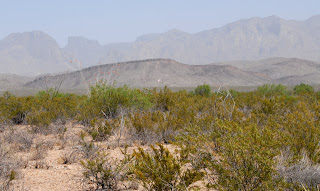
I'm not familiar enough with Big Bend to recognize the landmarks. I can just tell you that this is a pretty typical view in the desert areas of the park. 

This one, I do recognize. It's the Mule Ears Peaks.

I'll just call this one "Big Bend desert and mountains".
As I've mentioned before, I recently spent a week in the Big Bend area of Texas. With the daytime temperatures starting to soar, most tourists have left the area and only a few stragglers, such as myself, remained. On some of the days, the temperature was bearable, but most were really hot, dry and windy. I wasn't the only one to notice the challenging conditions. One day when I was in my trailer at the RV park in Terlingua, I looked out the window and noticed a worker watering the newly planted trees. He had built a small dike around the base of each tree and would fill it with a few gallons of water before moving on to the next one. No sooner had he left the area before one crow and four buzzards swooped down and landed at the base of the tree and began to drink the water. I realized at that point that I was truly living in the desert!

I'm currently in Alpine, Texas, which is only 80 miles north of the Terlingua area, where I was last week. There is something in this area that I wanted to see for myself. I'll tell you about that soon.

Until next time.


Wednesday, May 1, 2013

Nothin' works in the boonies!

As I was on highway 118,  just a few miles north of Study Butte, I saw this interesting rock...or mountain...I'm not sure. 

Here's a little closer look at it. 

The wind was kicking up a lot of dust on my first day in the park. This is on the western edge, not too far from Maverick Junction.
Hey! It's been awhile since I've created a new post but I have a good excuse. For the last week, I've been in Big Bend National Park in Texas and had my trailer stationed nearby in Study (pronounced Stoody) Butte. I found that getting online is practically impossible in either location and my phone only worked in a few areas and, even then, it only worked if I held my head just right. So, updating my blog wasn't an option.

Big Bend is a large park with a few main roads and a considerable number of dirt roads. The main east/west road is approx. 50 miles long and stretches from Maverick Junction on the western side, to Boquillas Canyon on the eastern side. From that road, there is a paved road that goes to Santa Elena Canyon, another to the Chisos Basin and a third to Persimmon Gap on the northern edge of the park. And of course, along each of those, there are many other places to stop and explore.

When I first entered the western edge of the park at Maverick Junction, I decided to take one of the dirt roads called Old Maverick Road which is approx. 13 miles long. It is essentially a short cut to Santa Elena Canyon. What I didn't know at the time is that it is 13 miles of dirt road that has a washboard surface and, if you're in a truck with stiff suspension like my F-250, it will beat you to death!!! I didn't think I was ever going to get off that road. Over the next 7 days, I visited Santa Elena Canyon several times but only once did I get there by taking Old Maverick Road.

I left Big Bend this morning and will spend the next couple of nights in Alpine, located only 80 miles north on highway 118. I took hundreds of photos while in Big Bend and will be posting some of those over the next few days or weeks.

Until next time.